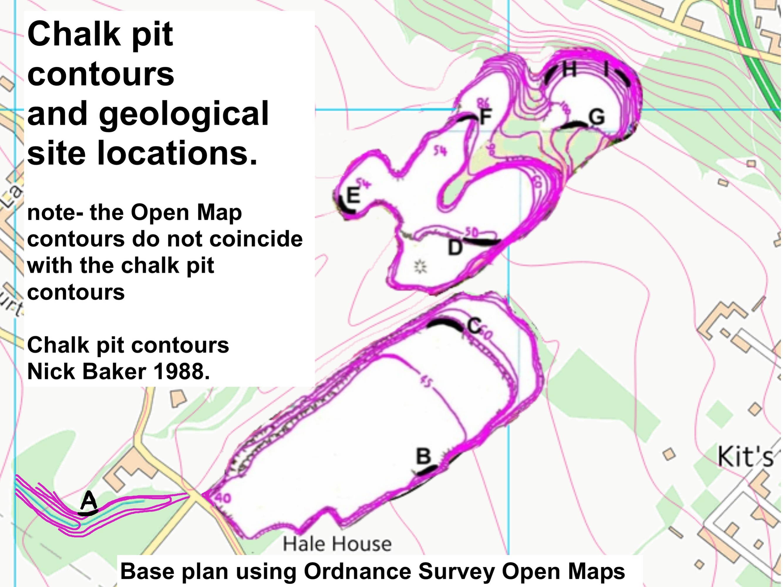
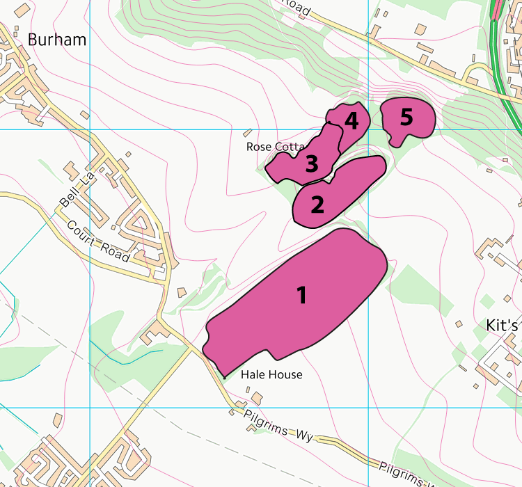
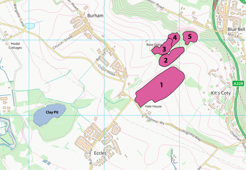
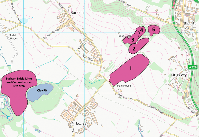
The pits under consideration comprise five separate sections in a cluster between Blue Bell Hill and the village of Eccles. Some documents refer to the Culand Pits, named after Great Culand Farm, which existed by the path on the north east side of pit 1. In some documents, pit 1 is referred to a the Lower Culand Pit and sections 2 to 5 as the Upper Culand Pit.
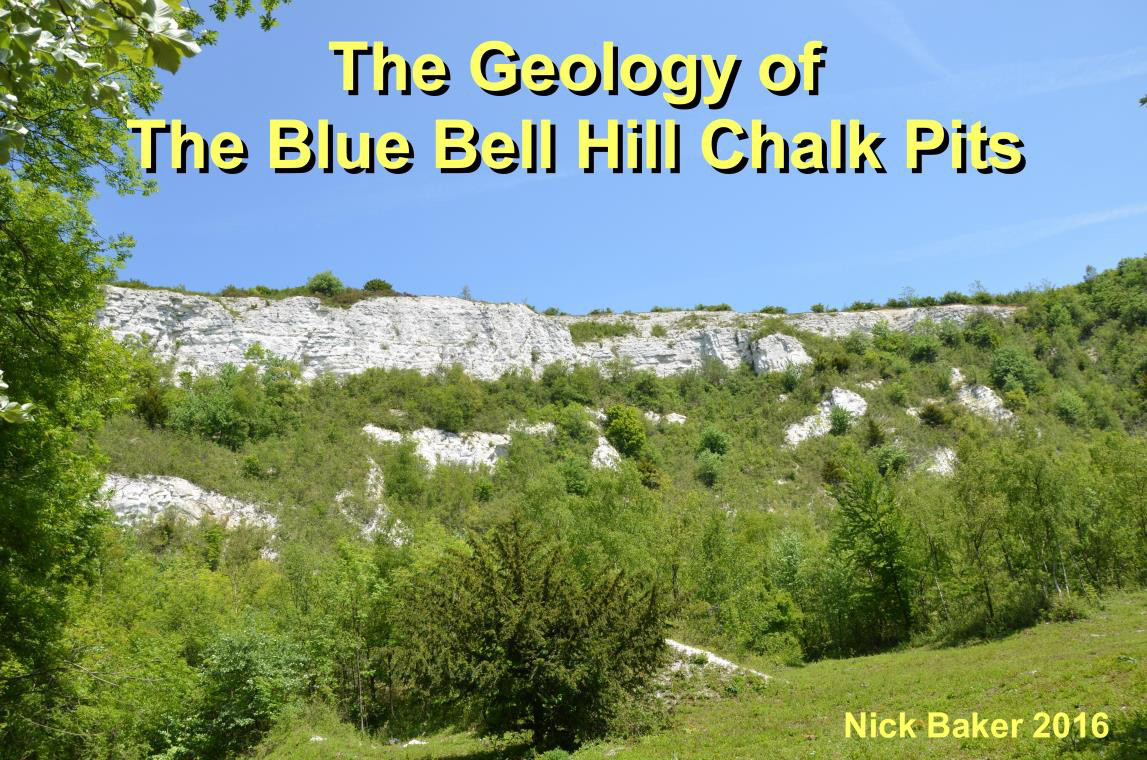
The five sections comprise an almost complete section from low in the Lower Chalk to the basal beds of the Upper Chalk. There are very few, if any, similar inland sections within Southern England. The uppermost pit were first worked in the early or mid 19th century, and the lower section worked until 1939.
The question arises as to why the pits are where they are. It is true that the Chalk is available in that location, but then the pits could be either further down the valley or to the east on another part of the downland. The close proximity of the River Medway could provide a clue in the need to transport the chalk, in the absence of a railway connection on the east side of the Medway.
Section 5 may have begun as a source of lime for the heavy Clay-With Flint land on the downland tops to the east. But working of the lower pits would have required a need closer to the west.
If we look at the neighbouring countryside to the west we note the large flooded clay pit to the northwest of Eccles and the rather disturbed ground to the west, towards the river. In the map below I have added the vast works to the northwest of the clay pit. In 1860, William Cubbett built the Burham Brick, Lime and Cement works. Initially the works produced bricks from the Gault Clay, and at its peak produced three million bricks per year. But Cubbett realised that the close proximity of the Chalk allowed for the production of another essential in the building industry, namely cement. In all of his production, Cubbett realised the need for efficient transport of materials, not just to and from the works but within the works itself
How big was the works? Well, We have a little watercolour made at the time.—1885
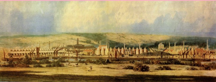
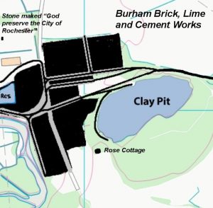
At its peak of working the works employed almost a thousand men and boys. Eccles village grew largely as a result of the works, while Burham and Ayles-ford also grew . Note the number of rail lines within the works itself. Cubbett could not rely on horse and cart and several steam locomotives were employed. This would be particularly important in the supply of chalk from the quarries to the east. Note the curious inscription on a stone to the north-west — “God preserve the City of Rochester”
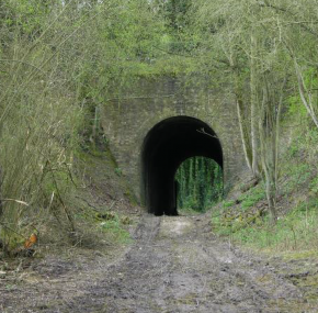
The first action was to construct a line from the works to sections number 2-3, including an 800m tunnel. This allowed easy transport of Chalk from the Upper Culand pit, especially sections 2, 3 and 4.
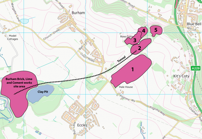

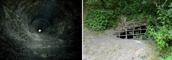
The photo of the tunnel was taken just to the NE of Petts Farm.
Today, the entrance in section 2 is gridded over to allow bats in and out, but to keep humans out.
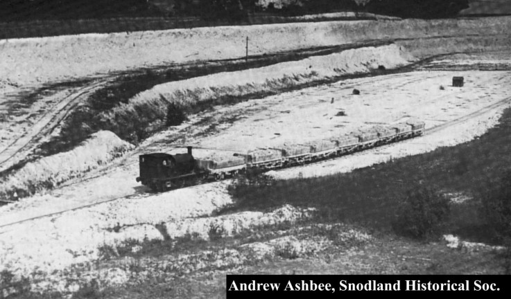
This is a picture of Culand Pit, probably c1930. The works used several locomotives, each capable of hauling up to 60 tons. Note the line going up to the upper level.
The yield of chalk from Lower Culand was slightly less than expected because of a high thickness of hillwash on the south side of the quarry.
Production at the works ended in 1939, partly due to the exhaustion of the chalk supply, but mostly due to difficulties in transporting cement away by river, due to shallowing of the Medway in the neighbourhood of the works.
Cement production continued on the west side of the Medway, at Snodland until quite late in the 20th century, facilitated much more by the rail line.
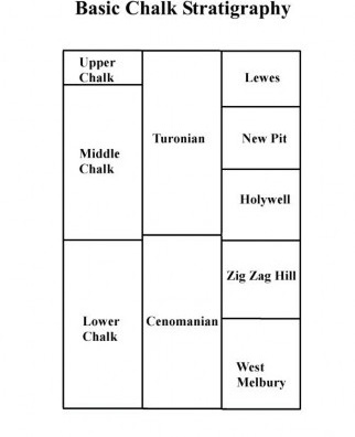
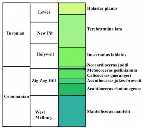
There are three major schemes that are used and the table on the right shows the levels of Chalk involved at Blue Bell Hill. First there is the classical subdivision of ‘Lower, Middle and Upper Chalk’. The Blue Bell Hill pits expose mostly the Lower and Middle Chalk, with just the basal beds of the Upper Chalk. Most of the older memoirs use this scheme. It is largely based on the lithology of the beds concerned.
Then there are the bio-divisions, based according to the fossil content. There are five major bio-divisions of the Upper Cretaceous, the Cenomanian, Turonian, Coniacian, Santonian, Campanian and Maastrichtian. In our area we are dealing with the first two of those. These divisions are further divided into fossil zones and sub-zones. In recent decades, Rory Mortimore and others have devised a refinement based on the lithology.
At Blue Bell Hill we have ‘West Melbury, Zig Zag Hill, Holywell, New Pit, and Lewes’. Note that the boundaries rarely appear to coincide and I will be dealing with this in a little more detail as we go along. Here on, I shall be dealing mainly with the bio-divisions and fossil zones.
I should also make mention of the stratigraphic work of Nick Robinson (c1980s) who used Kent- based terms for major divisions. I have retained his usage in some of the minor strata.
Below you will see how the fossil zones relate to the bio and lithostratigraphic systems. All the zones within the Cenomanian are ammonite zones. The Turonian is also subdivided into ammonite zones but, here I have kept to the older scheme of zoning.
The map below shows how the fossil zones are exposed in each of the pits. Note that the Cenomanian Chalk (cWest Melbury and Zig- Zag Hill) is exposed in pits 1,2 and 3, with the Turonian (cHolywell, New Pit, and Lewes) in pits 4 and 5.
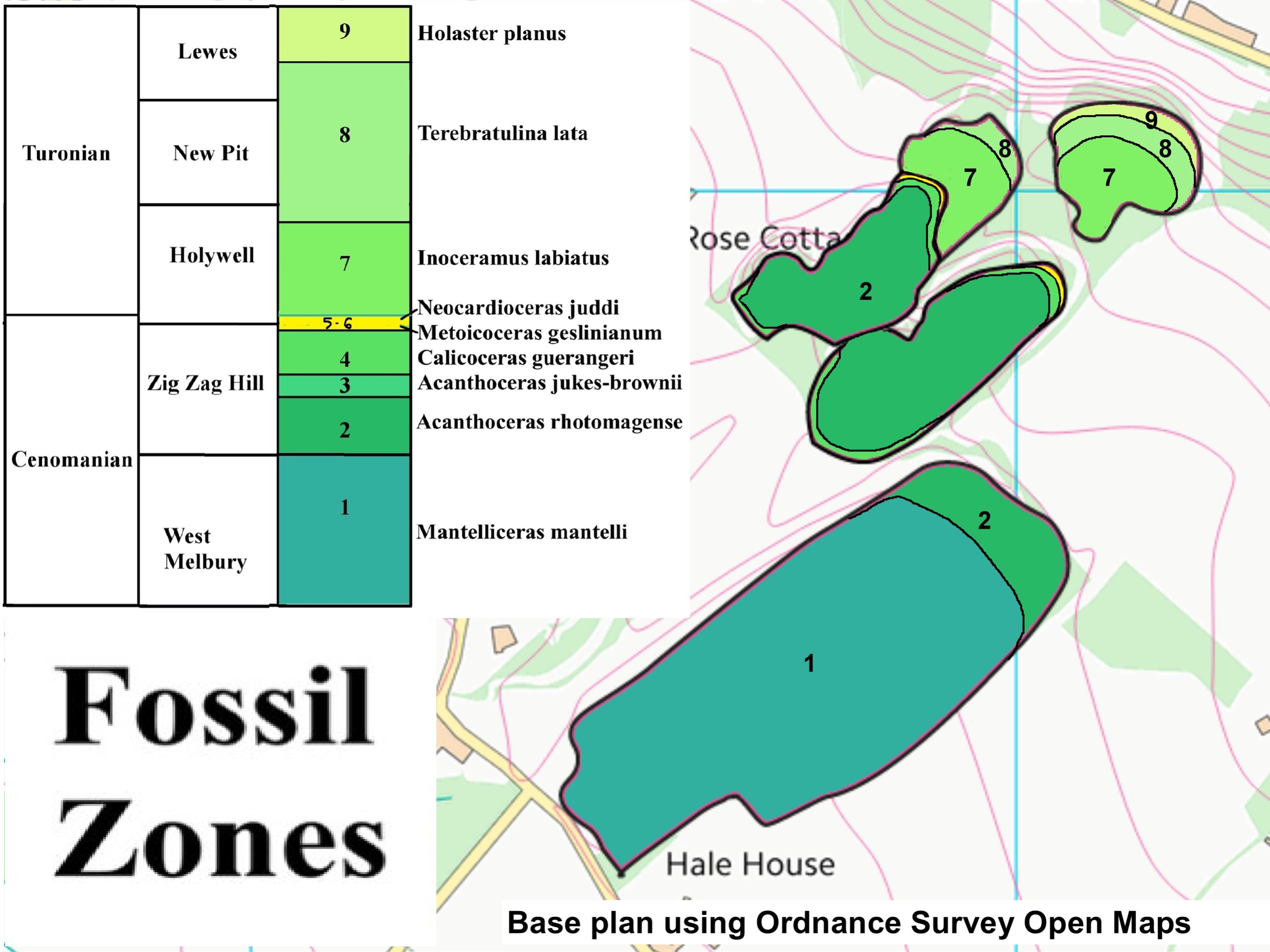
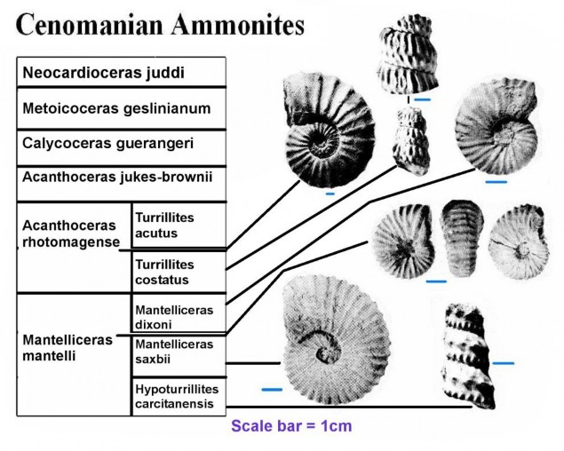
The ammonites are shown below. Note that the two lowest zones have been subdivided into further subzones. This was based on the work of Kennedy in 1969
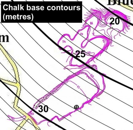
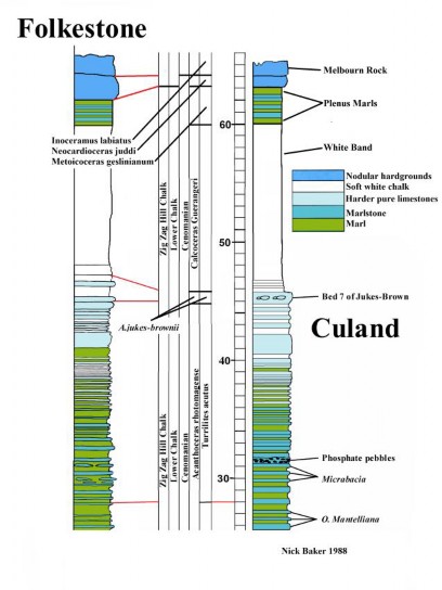
So, how much of the West Melbury Chalk do we have at Blue Bell Hill? The strat section on the right shows the relationship between Culand and Folke- stone. I have arrived at the figure of 23-24m of West Melbury Chalk, compared with 40m at Folkestone. How can the 23-24m thickness be derived for Culand? Below is a map showing the calculated altitude of the Chalk base in the local area. I am assuming a uniform dip with little or no faulting. The local strata tend to suggest this.
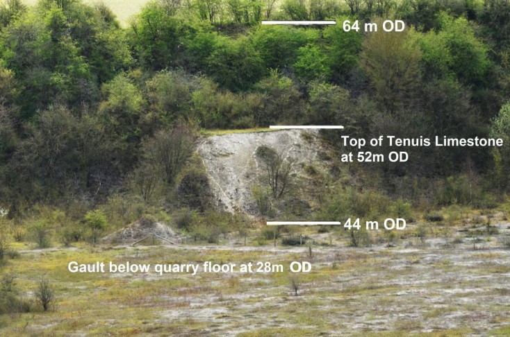
We know that the outcrop of the Gault in the rail cutting, SW of he Lower Culand pit, is at 32m OD. We also have to assume a little over 60m for the Lower Chalk in the local area. So we can deduce the position of the 25m and 20m contour, by the ele- vation of the top of the Plenus Marls (86m) in sec- tion 4, see map below. On the south east side of the Culand pit is a low cliff, the top of which is the Ten- uis Limestone, and thus the base of the West Melbury Chalk. At this point the Chalk base is c28m OD. Now, the top of the cliff is at 52m OD. This gives us 24m of the West Melbury Chalk.
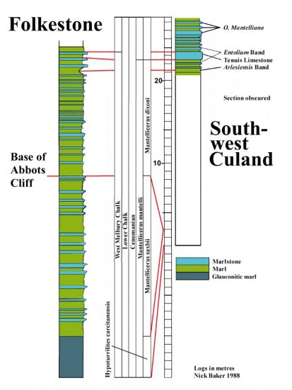
It is not certain what the West Melbury division con- tains. What we can say is that it is the Mantelliceras mantelli zone. We do not know what it is in terms of sub-zones. In 1991, the late Jim Craig (pers-comm) stated that the saxbii fauna was missing at Blue Bell Hill. Professor Gale has pointed out that the absence of hard limestone beds may not allow for the preser- vation of the diagnostic species i.e. M saxbii and M dixoni. In the rail cutting south west of the Lower Culand Pit there is a section of chalk about 8m above the Gault, The author does have several samples of micro fossils but has never found macro fossils at that location.
The remaining chalk from the top of the Tenuis Limestone to the top of the Plenus Marls will be about 40m, giving a Lower Chalk total of 63-64m. The base of the Chalk is not currently visible at Blue Bell Hill. A trench was dug in 1983 just west of Little Culand and showed Gault Clay and Glauconite Marl, but no visible section. The relative thinning of the West Melbury Chalk at Blue Bell Hill may be due to the late Cretaceous marine invasion advancing from the south east. The sediments at Folkestone may therefore be more stabilised—this situation then advancing northwestward. The thickness above the West Melbury Chalk is similar at Folkestone and Blue Bell Hill.
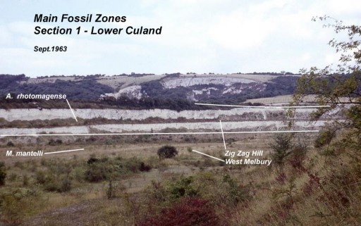
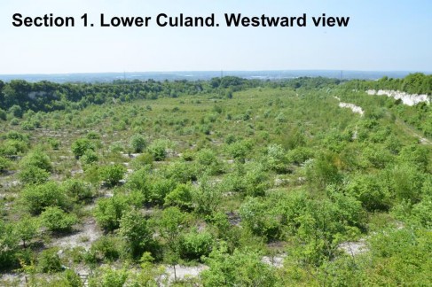
The picture to the right shows the main fossil zones at Lower Culand. We will now begin our tour and walk to the north-east end of the pit.
If we move towards the northernmost corner of the pit, the Tenuis Limestone dips below the floor of the pit.
We are now in the Zig Zag Hill Chalk and the Acanthoceras rhotomagense zone. The band containing the small brachiopod Orbirhynchia mantelliana is a marker bed near the base of the first cliff and this fossil is very common. Also in the scree we find the small solitary coral, Micraba- cia coronula, which is derived from a bed about half way up the first cliff. Two thick bands of hard marlstone can be seen in the cliff. This location is a rich source of fish and reptile remains and is a priori- ty location for preservation as a geological site over general wildlife. Another location would be the low bluff, previously shown, with the Tenuis Limestone at the top. This location is particularly rich in bivalves and brachiopods, as well as occasional ammonites and echinoids.
The second level is generally less fossiliferous but the scree below the upper cliff sometimes contains the large ammonite—Acanthoceras jukes-brownii, which is derived from a band just below the top ledge. This location is the viewpoint, looking westward into the pit. In the centre of the pit you can make out the former position of the rail line, which came up from the cement works.
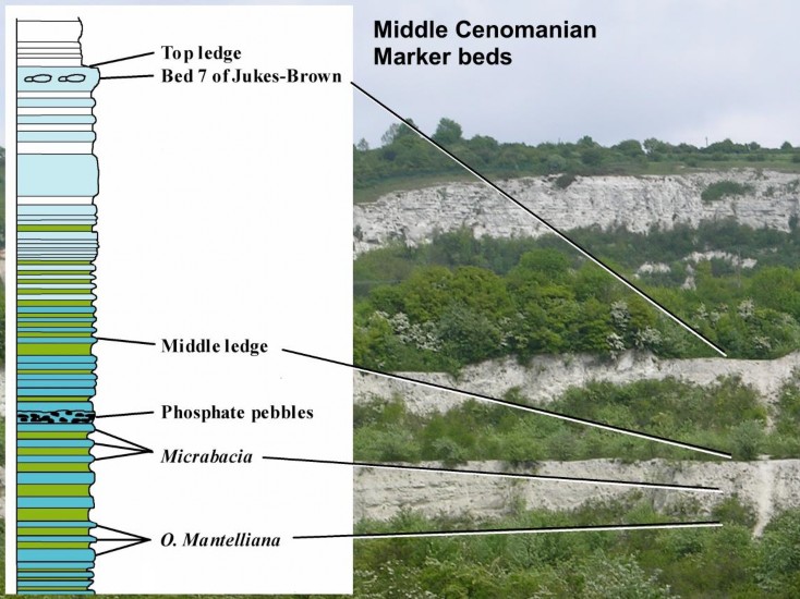
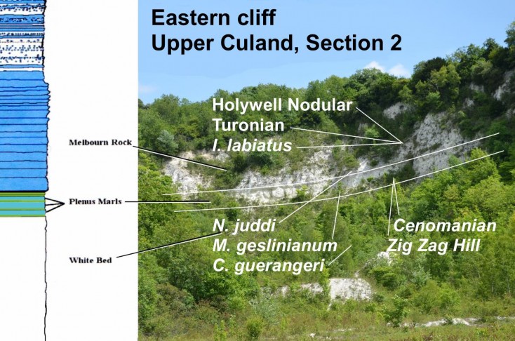
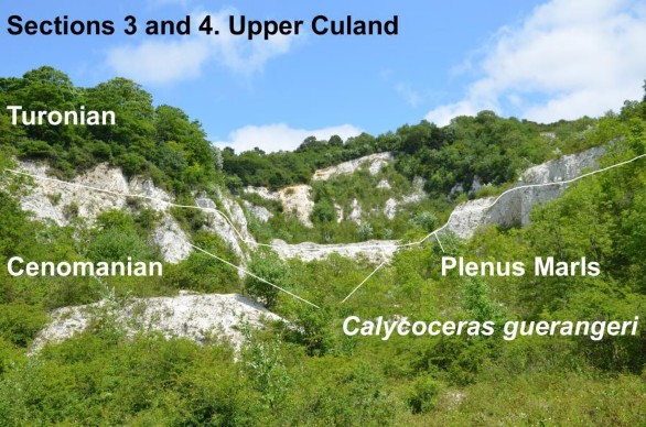
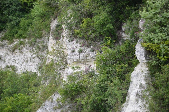
We arrive in sections two and three. In section two, the eastern cliff shows the Melbourn Rock in the top of the cliff, comprising the Turonian bio-division, Holywell Nodular Chalk, and Inoceramus labiatus zone. At the base of the Melbourne Rock is the zone of Neocardioceras juddi, which marks the top of the Cenomanian. Below this there is the Plenus Marls, named after the belemnite Actinocamax plenus, which is common in the marls. Below the marls is a band called the White Bed, which is part of the zone of Calycoceras guerangeri. This part of the Chalk is sparse in macro-fossils. Similar beds can be seen in section three, to the right. In the upper background is section 4, which will be described in a moment.
These two pictures show the Plenus Marls at the top of section 3. In the above picture the Marls appear to form the floor of section 4, while the picture below, taken more to the left, shows more of the overlying Melbourn Rock on slightly raised ground. A steep path below the centre of the cliff could be adapted (perhaps with steps) in order to build a viewing platform at the level of the Marls.
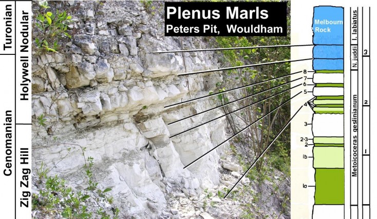
The Plenus Marls are named after the belemnite, Actinocamax plenus, which is quite common within these beds. R. P. S. Jefferies (proc Geol Soc Vol 74
(1) – 1963) did a lot of research into these beds and established the presence of eight identifiable compo- nent beds, generally marl, marlstone and normal chalk. All the beds comprise the Metoicoceras geslinianum zone. In the picture above we can see only beds 5 to 8. The top of the Marls mark the base of the Holywell Nodular Chalk, but in some recent papers, this boundary is applied to the base of the Marls. The top of the Marls has also been the boundary between the Lower and Middle chalk, although for many years, as late as the early 20th Century, the Marls were included in the Middle Chalk. The base of the Cenomanian lies just above the Marls and the lowest 50cm of the Melbourn Rock comprises the Neocardioceras juddi zone, the final bed of the Cenomanian.
The top of the Marls is c63 metres above the Gault, which agrees closely with bore hole records, and this confirms the reduced thickness of the West Melbury Division (c24 metres) compared with that at Folkestone (c40metres).
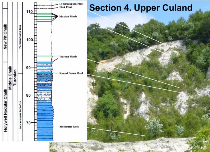
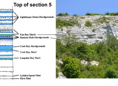
All that remains now is to continue our tour into the Middle and Upper Chalk (Turonian) (Holywell Nodular, New Pit and Lewes Nodular Chalk) – sections 4 and 5.
As can be seen from the photograph, section 4 is much overgrown and it is difficult to see the marker beds. The base of the section is occupied by the hard, semi-crystalline Melbourne Rock. Above that there is the remainder of the Holywell Nodular Chalk, within which, the Round Down Marl is the boundary of the Inoceramus labiatus and Terebratulina lata zones. The lower of the two Warren Marls marks the top of the Holywell Nodular Chalk. It is within the New Pit Chalk that the first flint bands occur. The First Flint marks the base of the Lewes Nodular Chalk. Finally, the Lydden Spout Flint is also a marker band at the type locality on the Kent Coast. We are now 112 metres above the Gault Clay.
Some clearance of the vegetation at the base of the cliff will help to maintain the Melbourn rock as a geological aspect, suitable for study, while keeping the rest of the site for general nature conservation.
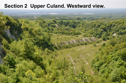
To the right is a view of Section 5, the highest section of the series. It contains the boundary of the New Pit and Lewes Nodular Chalk, as well as the Middle Chalk (Terebratulina lata) and Upper Chalk (Holaster planus). There is a distinct series of beds in the base of the planus zone, which we need to consider.
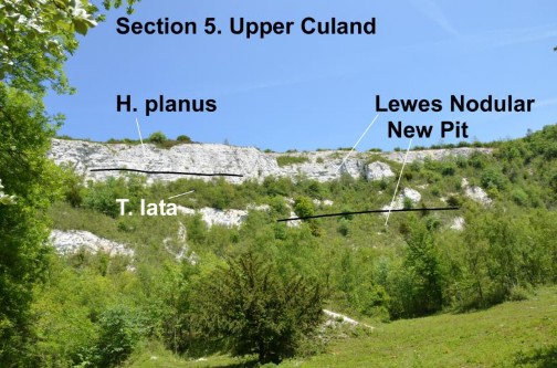
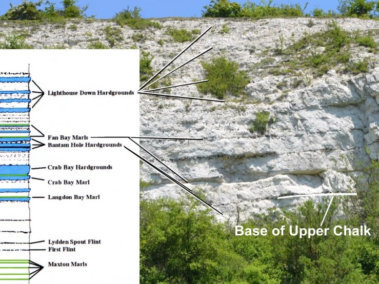
The base of the Upper Chalk is marked by a band of flints, amid a series of nodular hard- grounds, The Bantam Hole Hardgrounds. This is a small embayment on the Kent Coast between Langdon Bay and St Margarets. This is also the type location of the two ‘Fan Bay’ Marls. Further hardgrounds (The Lighthouse Down ) follow.
This may be the only remaining inland locality that show these beds. Others are now inaccessible or in-filled. The beds are much more fossiliferous than the Middle Chalk below. In this pit the beds are difficult to access but it is possible that step ways could be built into the scree. This might also be possible on the northwest side of the pit, in order to show the beds obscured in Section 4. The basal beds of the Upper Chalk are particularly rich in echinoids, especially Micraster, where these bed show the initial evolution from the Piaster series.
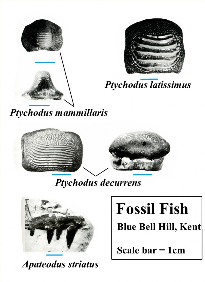
We have arrived at the end of our tour, but we need to just consider a few points on the geological conservation of the pits, taking into account other possible future developments. First of all, we need to look at some of the vertebrate fossils.
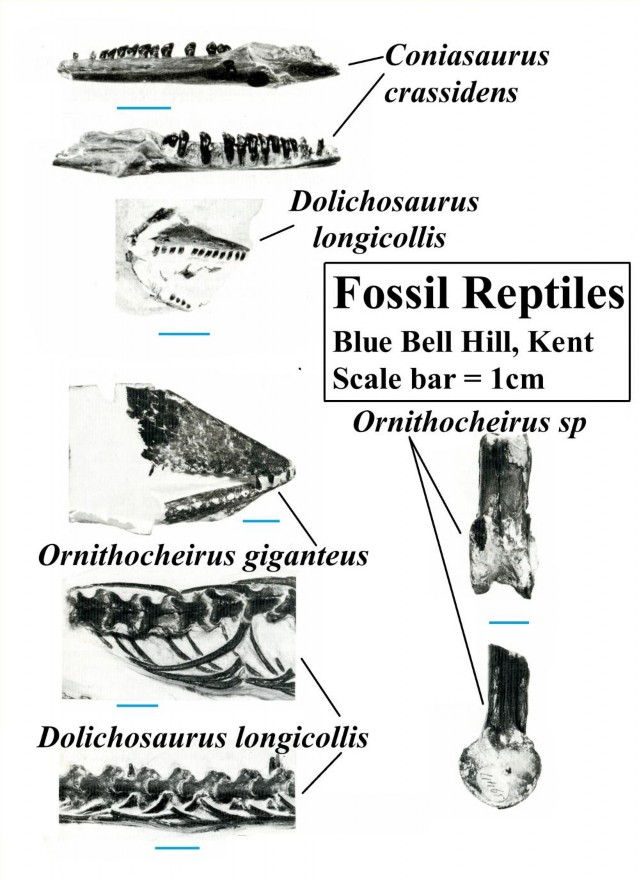
The Chalk at Blue Bell Hill, is noted more for the fossil reptiles rather than the fish. Fish remains are abundant in some localities, especially in the Zig Zag Hill division in sections 1, 2 and 3. The illustrations on this page are just are just a few examples of the many species found.
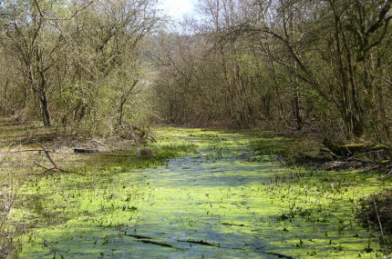
I cannot leave this account without some consideration of the development of the pits as geological sites, and also the possible future development of the pits as possible sites for housing development. In terms of the latter, these thoughts are my own and are not related to any current proposals. Nor, am I qualified as a geo-engineer. What follows is purely based on my observations of these sites in the past 55 years. Firstly, Lower Culand is notably damp. When I first saw the pit in February 1961, the whole south-western half was flooded. Flooding occurs most winters and in one in three the water depth is sufficient to set up a stream through the tram-way tunnel. The picture on the right was the situation in April 2014. The situation for Lower Culand is that it is close to the Gault—only about 5-10m above the Gault in the south-western end and thus has a high water table. The situation was the same at Holborough but there the village has been built on a rise (15-25m) above the lake and wetland. At Culand, the floor of the quarry rise 5m at most. In line with this, the access tunnel currently provides the only means of drainage.
Even if you do drain, the ingress of water means you are also draining the surrounding countryside. Lower Culand alone, receives 1000 tonnes of water with every 5mm of rain. In a wet year this could be 170,000 tonnes!
More immediately, there is a strong need for a roundabout to be built at the junction of the Burham-Eccles road. This means that at least 100m of the tramway cutting will have to be in-filled. This will necessitate, drainage pipes to be in-put though the tunnel and the infill. At what level do you put the pipes? If you are thinking of the wetland, then you put them at the floor-level of the tunnel. If you think in terms of housing, you put them several metres lower. So, you do not wait for a decision on the housing. You do the latter and wave goodbye to the wetland.
Let us consider what happens assuming the status quo is maintained. Usually, with regard to conservation, natural history and geology do not mix well. Lower Culand, as a wildlife site has, effectively, been shut off from any geological potential. The fencing had to shut off the cliffs from the browsing of the imported goats (but why barbed wire?)
The goats were imported to keep down the haw- thorne, wild rose, wayfaring tree, and buddleia, in order to encourage chalk grassland. Now, there is chalk grassland in sections 2, 3 and 5 (see to right). This may be because these sections are dryer. Lower Culand has never showed signs of producing grass, except on the screes. The environment is unique, not as grassland, but as bare chalk land.
I believe it is possible to maintain the geological potential, by active conservation, and not let it all go under lock and wire. All that is really required is the maintenance of several short sections. At each section a gap is allowed and the fence is rerouted up to the cliff, and keeping the screes free of vegetation.
There are several sites.
A: In the tramway cutting. Maintaining the cliff on the north side—this being the oldest chalk in the pits, just eight metres above the Gault. It will, of course, be cut off from the main pits, but it should be well to the west of any proposed in-fill.
B: The low bluff, exposing the Tenuis Limestone and the base of the West Melbury division.
C, D, E: Several sections in the Zig Zag Hill division, exposing classic marker beds and rich sites of fish and reptile remains.
F: A steep slope in section 3, climbing to section 4—replacement by steps and a possible viewing-point level with the Plenus Marls.
G: In section 5 near the entrance, several sections near the junction of the Holywell nodular and New Pit division.
H: In the scree on the north side, steps to close-view the marker beds in the New Pit division and base of the Lewes Nodular division.
I: The highest beds in section 5 are the least accessible. Steps might be put in the scree to allow a closer viewpoint.
With regard to the future collection of fossils—it could be done on a permit basis, with the promise by the finder that any items of special interest should be shown to the future owners of the sites and/or local experts/museums.
In former years, the chalk pits have been accessible to a greater or lesser degree. On a website, entitled “growing up in Eccles”, nearly all the children listed one of their main activities as “exploring the old chalk pits”.
Nick Baker, May 2016